All the way to the distant skyline. Sightseeings, greenways in European, Israeli nature, towns, pictures, photo extreme tours from usual life. Black and white photo
I was advised to visit these places in August. In August, it is usually the pink jellyfish season. They are harmless but very fun. If you find them this is usually an indication that the water in that area is pristine. The water in beaches very clean in the beaches compared to the harbour area.
It is really worth travelling a bit further down the spit. You can reach Juodkrante, it’s the first resort which is about 15 km away from the ferry if you are extreme cyclist. You can even rent bicycles in the old crossing, and take them with you. Just beside this beach there goes the good cycling track.
But there are wild flowers blooming everywhere and you will surely get a touch of the nature. You won’t see many dunes on the way, but you will see beautiful pine forests… Anyway in the bicycle case you can see more wild nature and even manage to find a private spot somewhere on the beach.
Photos taken on May, 7-8, 2017
The Curonian Spit is a unique and vulnerable, sandy and wooded cultural landscape on a coastal spit which features small Curonian lagoon settlements. The Spit was formed by the sea, wind and human activity and continues to be shaped by them. Rich with an abundance of unique natural and cultural features, it has retained its social and cultural importance. Local communities adapted to the changes in the natural environment in order to survive. This interaction between humans and nature shaped the Curonian Spit cultural landscape.
The history of the Curonian Spit is dramatic: 5,000 years ago, a narrow peninsula (98 km in length and 0.4-3.8 km in width), the Great Dune Ridge separating the Baltic Sea from the Curonian Lagoon, was formed on moraine islands from sand transported by currents, and later covered by forest. After intensive logging in the 17th and 18th centuries, the dunes began moving towards the Curonian Lagoon, burying the oldest settlements. At the turn of the 19th century, it became evident that human habitation would no longer be possible in the area without immediate action. Dune stabilisation work began, and has continued ever since. By the end of the 19th century, a protective dune ridge was formed along the seashore to prevent inland sand migration, and the Great Dune Ridge was reinforced using trees and brushwood hedges. Currently, forests and sands dominate the Curonian Spit. Urbanised areas (eight small settlements) cover just about 6% of the land.
unesco.org
Curonian Spit 360 panorama
https://unavitaverde.net/wp-content/uploads/2017/05/s_IMG_4632.jpg666888unavita//unavitaverde.net/wp-content/uploads/2022/07/verde_wanderer_logo_new.pngunavita2023-02-01 11:18:422023-05-17 08:30:14Sands of the Curonian Spit. Klaipeda, Lithuania.
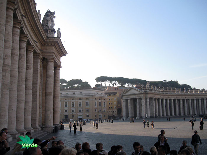
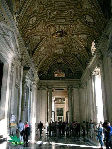
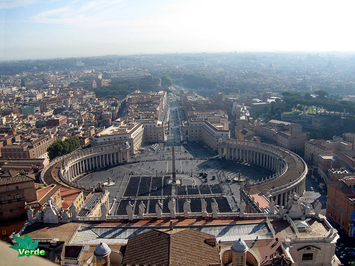
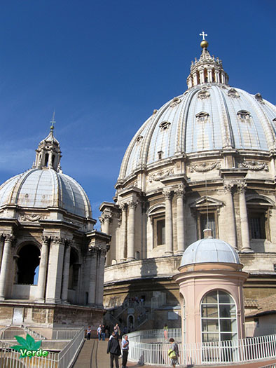
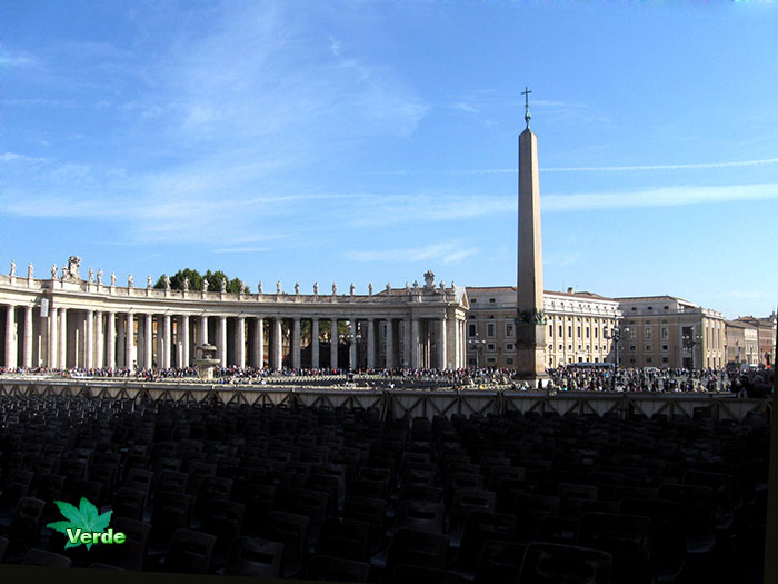
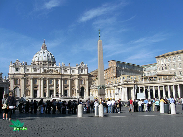
The name “Vatican” predates Christianity and comes from the Latin Mons Vaticanus, meaning Vatican Mount. The territory of Vatican City is part of the Mons Vaticanus, and of the adjacent former Vatican Fields. It is in this territory that St. Peter’s Basilica, the Apostolic Palace, the Sistine Chapel, and museums were built, along with various other buildings. The area was part of the Roman rione of Borgo until 1929. Being separated from the city, on the west bank of the Tiber river, the area was an outcrop of the city that was protected by being included within the walls of Leo IV (847–55), and later expanded by the current fortification walls, built under Paul III (1534–49), Pius IV (1559–65) and Urban VIII (1623–44).
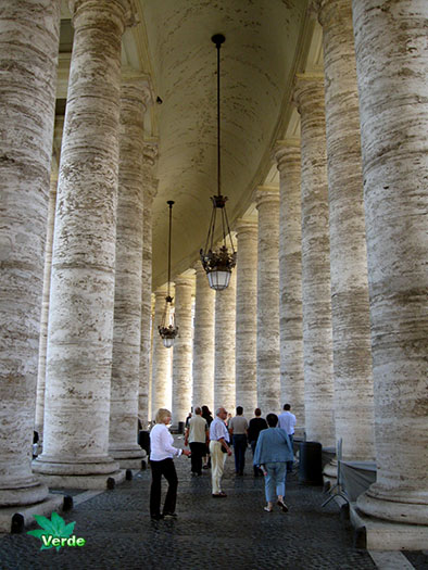
See photos of Vatican City (including Vatican & Rome panoramic views, Saint Peter’s Square and interior of St.Peter’s Basilica panoramic views, interactive map of Vatican and more) in this travel photo gallery from Verde Wanderer. Pictures taken at 10 of October, 2008.
A now about History
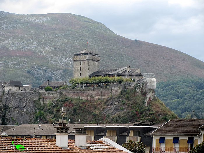
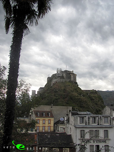
During the 8th century, Lourdes and its fortress became the focus of skirmishes between Mirat, the local leader, and Charlemagne, King of the Franks. Charlemagne had been laying siege to Mirat in the fortress for some time, but the Moor had so far refused to surrender. According to legend, an eagle unexpectedly appeared and dropped an enormous trout at the feet of Mirat. It was seen as such a bad omen that Mirat was persuaded to surrender to the Queen of the sky by the local bishop. He visited the Black Virgin of Puy to offer gifts, so he could make sure this was the best course of action and, astounded by its exceptional beauty, he decided to surrender the fort and converted to Christianity. On the day of his baptism, Mirat took on the name of Lorus, which was given to the town, now known as Lourdes.
After being the residency of the Bigorre counts, Lourdes was given to England by the Brétigny Treaty which bought a temporary peace to France during the course of the Hundred Years War with the result that the French lost the town to the English, from 1360. In 1405, Charles VI laid siege to the castle during the course of the Hundred Years War and eventually captured the town from the English following the 18-month siege. Later, during the late 16th century, France was ravaged with the Wars of Religion between the Roman Catholics and the Huguenots. In 1569, Count Gabriel de Montgomery attacked the nearby town of Tarbes when Queen Jeanne d’Albret of Navarre established Protestantism there. The town was overrun, in 1592, by forces of the Catholic League and the Catholic faith was re-established in the area. In 1607, Lourdes finally became part of the Kingdom of France.
The castle became a jail under Louis XV but, in 1789, the General Estates Assembly ordered the liberation of prisoners. Following the rise of Napoleon in 1803, he again made the Castle an Estate jail. Towards the end of the Peninsular War between France, Spain, Portugal, and Britain in 1814, British and Allied forces, under the Duke of Wellington, entered France and took control of the region and followed Marshall Soult’s army, defeating the French near the adjoining town of Tarbes before the final battle took place outside Toulouse on 10 April 1814 which brought the war to an end.
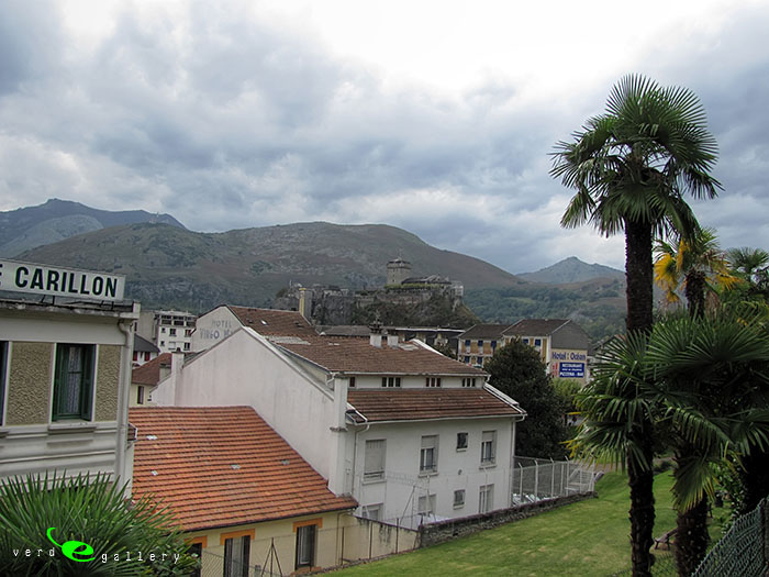
Up until 1858, Lourdes was a quiet, modest, county-town with a population of only some 4,000 inhabitants. The castle was occupied by an infantry garrison. The town was a place people passed through on their way to the waters at Barèges, Cauterets, Luz-Saint-Sauveur and Bagnères-de-Bigorre, and for the first mountaineers on their way to Gavarnie, when the events which were to change its history took place.
On 11 February 1858, a 14-year-old local girl, Bernadette Soubirous, claimed a beautiful lady appeared to her in the remote Grotto of Massabielle. The lady later identified herself as “the Immaculate Conception” and the faithful believe her to be the Blessed Virgin Mary. The lady appeared 18 times, and by 1859 thousands of pilgrims were visiting Lourdes. A statue of Our Lady of Lourdes was erected at the site in 1864.
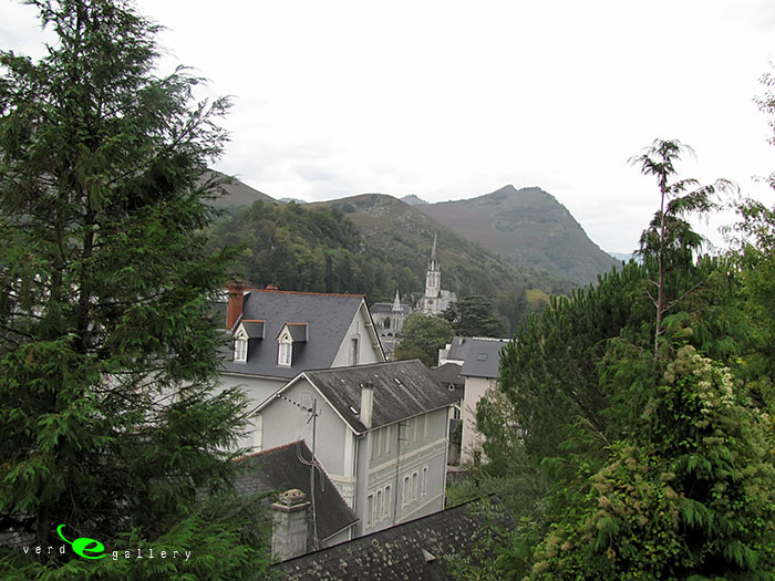
Sanctuary of Lourdes
On 11 February 1858, Bernadette Soubirous went with her sisters Toinette and Jeanne Abadie to collect some firewood and bones in order to be able to buy some bread. When she took off her shoes and stockings to wade through the water near the Grotto of Massabielle, she said she heard the sound of two gusts of wind (coups de vent) but the trees and bushes nearby did not move. She said she saw a light in the grotto and a girl, as small as she was, dressed all in white, apart from the blue belt fastened around her waist and the golden yellow roses, one on each foot, the colour of her rosary. Bernadette tried to keep this a secret, but Toinette told her mother. After parental cross-examination, she and her sister received corporal punishment for their story.
Three days later, Bernadette returned to the Grotto with the two other girls. She had brought holy water as a test that the apparition was not of evil provenance; however, she said, the vision only inclined her head gratefully when the water was thrown.
Bernadette’s companions reportedly became afraid when they saw her in ecstasy. Bernadette remained ecstatic when they returned to the village. On 18 February, she said she was told by the Lady to return to the Grotto over a period of two weeks. She quoted the apparition: I promise to make you happy not in this world but in the next.
After the news spread, the police and city authorities began to take an interest. Bernadette was prohibited by her parents and police commissioner Jacomet to ever go there again, but she went anyway. On 24 February, Bernadette said, the apparition asked for prayer and penitence for the conversion of sinners. The next day, she said she was asked to dig in the ground and drink the water of the spring she found there. This made her disheveled and caused dismay among her supporters, but revealed the stream that soon became a focal point of pilgrimage.
At first muddy, the stream became increasingly clean. As word spread, this water was given to medical patients of all kinds, and numerous miracle cures were reported. Seven of these cures were confirmed as lacking any medical explanations by Professor Verges in 1860. The first person with a “certified miracle” was a woman whose right hand had been deformed as a consequence of an accident. Several miracles turned out to be short-term improvement or even hoaxes, and Church and government officials became increasingly concerned. The government fenced off the Grotto and issued stiff penalties for anybody trying to get near the off-limits area. In the process, Lourdes became a national issue in France, resulting in the intervention of emperor Napoleon III with an order to reopen the grotto on 4 October 1858. The Church had decided to stay away from the controversy altogether.
Bernadette, knowing the localities rather well, managed to visit the barricaded grotto under the protection of darkness. There, on March 25, she said she was told: “I am the Immaculate Conception” (“que soy era immaculada concepciou”). On Easter Sunday, 7 April, her examining doctor stated that Bernadette, in ecstasy, was observed to have held her hands over a lit candle without receiving any burns. On 16 July, Bernadette went for the last time to the Grotto. I have never seen her so beautiful before, she reported.
The Church, faced with nationwide questions, decided to institute an investigative commission on 17 November 1858. On 18 January 1860, the local bishop finally declared that: The Virgin Mary did appear indeed to Bernadette Soubirous. These events established the Marian veneration in Lourdes, which together with Fátima, is one of the most frequented Marian shrines in the world, and to which between 4 and 6 million pilgrims travel annually.
The verity of the apparitions of Lourdes is not an article of faith for Catholics. Nevertheless, all recent Popes visited the Marian shine. Benedict XV, Pius XI, and John XXIII went there as bishops, Pius XII as papal delegate. He also issued, with Le Pelerinage de Lourdes, an encyclical on the hundredth anniversary of the apparitions in 1958. John Paul II visited Lourdes three times and Pope Benedict XVI completed a visit there on 15 September 2008 to commemorate the 150th anniversary of the apparitions in 1858.
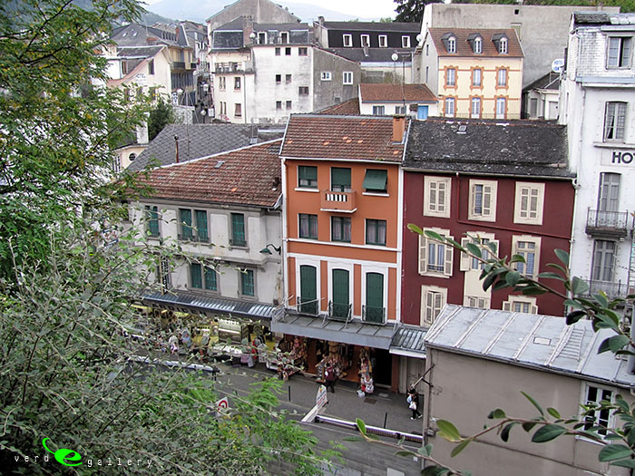
See Lourdes photos, France (including Our Lady Sanctuary photos, Grotto photo, Lourdes street photos, Lourdes railway photos and more) in this travel photo gallery from Verde Wanderer. Pictures taken at 9 of October, 2010 and added to Lourdes photo gallery.
https://unavitaverde.net/wp-content/uploads/2014/10/lourdes_cover.jpg420560unavita//unavitaverde.net/wp-content/uploads/2022/07/verde_wanderer_logo_new.pngunavita2023-02-01 10:20:122023-05-17 08:39:22Our Lady of Lourdes, France
Pine forests grow on poor and dry soils, and have a simple tiered structure and the relatively poor fauna. These forests have not the diversity of the species, the leading land-based way of life. The fauna of spruce forests richer than the pine forests because it has the best protective properties for the animals. Also, spruce forests provide a favorable microclimatic conditions in the wintering period, which attracts animals from other habitats.
Album include the several photos of the Gold autumn series from October, 2012.
Pictures taken on 19 of October, 2012; 12 of July, 2008; 2 of September, 2007; 4 of July, 2015.
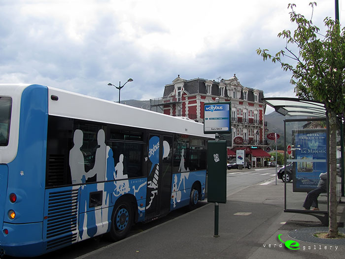
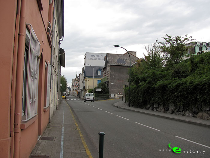
The old town is not very big but very interesting. You need flat shoes for easy walk around, a streets cobbled with stones. Also you will need some transport if you like to visit not just old town, but some other places at town.
Photos taken on May, 7-8, 2017.
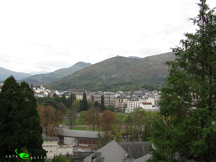
Klaipėda is a city in Lithuania on the Baltic Sea coast. It is the third largest city in Lithuania and the capital of Klaipėda County.
The city has a complex recorded history, partially due to the combined regional importance of the usually ice-free Port of Klaipėda at the mouth of the Akmena-Danė River. It was controlled by successive German states until the 1919 Treaty of Versailles. As a result of the 1923 Klaipėda Revolt it was added to Lithuania and has remained with Lithuania to this day, except for the period between 1939 and 1945 when it returned to Germany following the 1939 German ultimatum to Lithuania.
The population has shrunk from 207,100 in 1992 to 157,350 in 2014. Popular seaside resorts found close to Klaipėda are Nida to the south on the Curonian Spit, and Palanga to the north.


")
")


